Go outside on any clear, dark night, far away from the lights of a town or city, and you’re looking at the stars as the ancients once did. Or are you? Arguably, that hasn’t been the case for decades, especially since October 4th, 1957, when the Soviet Union launched Sputnik I - the world’s first artificial satellite.
Since then, roughly 25,000 satellites have been successfully launched into Earth orbit. To break it down, that works out to an average of about 366 a year, or roughly 30 every month.
As of early February 2026, there are 14,518 active satellites in orbit, with 9,555 of those being active Starlinks. That’s an awful lot of satellites. But what are they? What do they do? And how can you see them for yourself?
What Kinds of Satellites Can You See?
Say the word satellite to many people, and they might imagine something like the Hubble Space Telescope; maybe something cylindrical, with large solar panels. Ask folks what they do, and they’ll probably give you a wide range of answers, including TV, internet, weather, and military. Of course, it’s a little more complicated than that, so let’s take a closer look.
Not every satellite orbits at the same distance, or altitude, from the Earth, with a satellite’s purpose often defining how far away it needs to be. Broadly speaking, when it comes to distance, satellites can be categorized into one of three groups: LEO, MEO, and GEO.
LEO - Low Earth Orbit
Accounting for roughly 90% of satellites in orbit, this group makes up the vast majority. Low Earth orbit is defined as anywhere between 99 miles (160 km) and 1,243 miles (2,000 km), but few will orbit lower than 125 miles (200 km) due to atmospheric drag. Most of these orbit at a distance of roughly 300 - 375 miles (482 - 603 km) from the Earth. Comparatively speaking, that’s pretty close (remember, the Moon is 239,000 miles, or 149,000 km away), which makes them fairly easy to see with the naked eye.
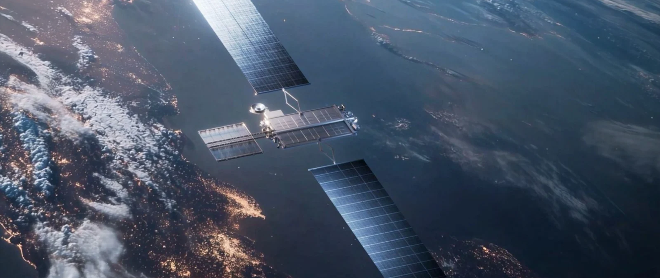
The vast majority of LEO satellites are related to communications in some way, such as TV and internet. As mentioned above, SpaceX holds the record in this regard, with over 9,500 Starlink satellites in orbit around Earth. Of the rest, the second most common are Earth observation and remote sensing satellites. These study and monitor the Earth, tracking environmental changes, such as vegetation, ocean temperature, and polar ice, as well as monitoring the atmosphere for changes in pollutants and ozone. Beyond that, there are also science satellites (such as Hubble), weather, and military satellites.
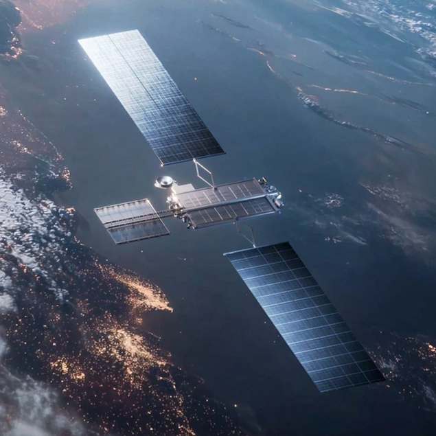 Image Credit: SpaceX
Click to Enlarge Image
Image Credit: SpaceX
Click to Enlarge Image
The Other 10%: MEO and GEO
Far fewer in number are the MEO (Medium Earth Orbit) and GEO (Geosynchronous Earth Orbit) satellites, with current numbers estimated at about 265 for MEO and 570 for GEO.
Medium Earth Orbit satellites typically operate at altitudes of between 1,243 miles (2,000 km) and 22,060 miles (35,500 km), with navigation satellites (such as GPS) accounting for roughly 40% of those. MEO satellites are harder to spot because they orbit farther away than their low Earth companions, and are therefore fainter. GEO satellites orbit at a distance of 22,236 miles (35,786 km) above the Earth’s surface, or 26,199 miles (42,164 km) from the center of the Earth. These are either geostationary or geosynchronous satellites, and there’s a subtle difference between the two.
A geosynchronous satellite takes the same amount of time to orbit Earth as the Earth takes to rotate once, so it shows up in roughly the same part of the sky at the same time each day. However, it may still drift a little, tracing a small loop or figure-eight pattern over 24 hours. A geostationary satellite is a specific type of geosynchronous satellite: it orbits directly above the equator in a circular path, so it stays parked over one fixed point on Earth and appears not to move.
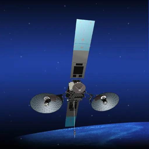 Image Credit: NASA
Click to Enlarge Image
Image Credit: NASA
Click to Enlarge Image
These typically maintain continuous communication with the ground and include broadcasting satellites, weather, missile warning systems, and support networks for spacecraft. A good example is NASA’s Tracking and Data Relay Satellites (TDRS), which relay communications for missions in lower orbits. Their distance from Earth makes GEO satellites faint and difficult to spot. You’ll need to have good eyesight (or binoculars), be under dark skies, and know exactly what to look for.
What Else is Up There?
Besides the types of satellites already mentioned, there is also evidence of human spaceflight in the skies above. The most obvious example is the International Space Station (ISS), which is easily visible to the naked eye - even from light-polluted suburban skies. The first component of the ISS, the Russian Zarya control module, was launched in November 1998, with the first crew arriving two years later. The station has been continuously manned with a crew of seven astronauts and cosmonauts ever since, so each time you look up at the station, there’s a decent chance someone might be looking down at you!
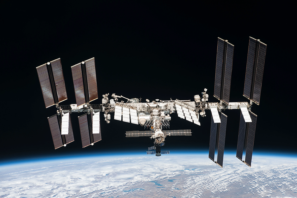 Image Credit: NASA
Click to Enlarge Image
Image Credit: NASA
Click to Enlarge Image
Since 2022, China has had its own space station, Tiangong, which operates under similar circumstances with a crew of three. Being smaller, it’s not as bright as the ISS, but it is still visible to the naked eye. Both operate at similar altitudes, with the ISS typically orbiting between 250 and 260 miles from Earth (400 - 420 km) and Tinagong orbiting the Earth at an altitude of between 210 and 280 miles (340 - 450 km).
If the timing is right, you could also see crewed spacecraft and cargo vehicles as they ferry to and from the space stations, but you’ll need to know the specific details of the launch and flight path to stand a chance of seeing them. Lastly, you might also catch sight of space junk: defunct satellites or spent rocket stages. While most of this is too small and travels too fast to be easily seen with the naked eye, you might occasionally see something if it’s large enough.
The End of an Era - Iridium Flares
Speak to anyone who’s been watching satellites for a while, and they’ll tell you about Iridium flares. The Iridium satellites supported voice and data communications for satellite phones and other devices, and provided coverage over the oceans and poles.
The satellites were highly reflective, causing them to flare in brightness for a few seconds as sunlight struck their surface. However, the satellites were retired and replaced over a period of two years, from early 2017 to 2019, with the replacement NEXT satellites having less reflective surfaces. The last of the original Iridium satellites was deorbited in December 2019, thereby bringing the famous flares to an end.
Satellite Spotting - A Beginner’s Guide
Spotting satellites with the naked eye is relatively easy once you know when to look and what to look for.
Unlike astronomy, which is best enjoyed when the night is darkest, prime time for satellite spotting is during the evening or predawn twilight. At that time, the sun is below the horizon on Earth, but still above the horizon in space. This allows sunlight to shine directly onto the satellite, which makes it stand out against the darkened twilight sky.
There’s a trick to the timing; step outside too early before sunrise or too late after sunset, and you might find it hard to see the satellites. The sky is dark, but with the Sun too far below the horizon, little or no light will reach the satellite, making it difficult to see. Conversely, if it is too close to sunrise or sunset, the sky will be too bright.
With this in mind, the sweet spot is usually about an hour to two hours before sunrise or after sunset, when the Sun is between 6 and 12 degrees below the horizon. In astronomical terms, you’ll want to be outside during nautical twilight.
What Sets Satellites Apart From Stars and Aircraft
As the satellite orbits the Earth, you’ll see it move against the backdrop of stars. You may first notice it as a relatively faint point of light, but as the satellite moves closer, it will gradually brighten before fading away again. Most satellites typically brighten to magnitudes 4-6, but some are closer to magnitude 3 or brighter.
Besides the movement and change in brightness, there’s something else that sets satellites apart from stars: they don’t twinkle. However, they do “glint,” thanks to the satellites’ surfaces reflecting sunlight as they move and spin through space.
When you first spot a satellite, you might immediately pass over it as just another star. But then you’ll notice the “star” slowly moving; you might also see it slowly brighten and flicker in a way that’s not quite starlike. You might also think it’s an airplane, but there are a few tell-tale signs that give the game away:
- They’re typically fainter
- They don’t have red and blue lights
- They often move more slowly
- Aircraft lights will blink alternately
Keep your eye on your target, and you’ll notice satellites doing something else that stars and aircraft don’t do - fade. Depending on the satellite, it might brighten quickly but then fade just as quickly. Chances are, it might disappear completely, leaving you wondering if you saw anything at all!
Lastly, many of the satellites you’ll see move from the western hemisphere of the sky to the eastern hemisphere. This is because most LEO satellites are in prograde orbits and move in the same direction as Earth's rotation.
Must-See Satellites - The ISS & Starlink
As mentioned earlier, the easiest “satellite” to see is the International Space Station, or ISS. This is one target that’s big, bright, and almost unmissable. In fact, once you become familiar with it, you might even be able to identify it on a random night without foreknowledge of its appearance.
It’s not unusual for the ISS to appear a little like Jupiter - it often has a slightly golden hue and is frequently around the same brightness as the giant planet. On particularly good passes, the ISS can even appear brighter than Venus.
Starlink satellites are a little different. Unlike traditional satellites, they’re launched in clusters of around 25 at a time. From around 1 to 3 days after launch (sometimes more), you’ll see them drift across the sky as a chain of lights, but the longer you wait, the further apart the satellites will appear as they drift apart and move into higher orbits.
Tools For Tracking Satellites
When it comes to tracking and identifying satellites, there are, of course, apps for that. However, before we go into the details, let’s first consider a couple of apps that can give you a heads-up of upcoming launches: Next Spaceflight and Space Launch Now.
Both provide all the details you need for the launch, including links to watch the launch live. However, Space Launch Now is a fantastic resource for facts and figures, while Next Spaceflight provides a useful simulation of the launch to help you get an idea of whether it will be visible from your location. When it comes to tracking the satellites themselves, all the apps mentioned below will give you the information you need, including timings and altitudes, but some will go the extra mile.
Heavens Above
The most comprehensive of the apps: even the free version is feature-rich with a real-time view of the sky and icons representing the satellites that are currently visible. By moving the bar along the bottom, you can adjust the time and simulate the sky for almost any time. Another handy feature is the Daily Events, which allows you to see what’s expected to be coasting across the sky tonight.
Pretty much every kind of satellite is tracked, including the ISS, regular satellites, and rocket stages. In addition to the standard rising/setting information, it will also provide a magnitude estimate, orbital data, and information about the satellite itself.
The downside is that the app is only available on Android devices, while iPhone owners will need to use their website.
ISS Detector
An easy-to-use app, ISS Detector does more than predict passes of the International Space Station. Aimed at casual astronomers and satellite spotters, the app will highlight the Moon and planets, as well as Starlink and China’s Tiangong station. There’s a depiction of the sky so you know where to look, and icons indicating the predicted weather conditions and brightness.
The ISS Detector app is available for both Android and iOS devices.
See A Satellite Tonight
Simple and free, this app is designed to get you outside and looking up, but you’ll need an internet connection. There are three standout features: first, tiles along the top show the best satellite passes for the next five days, making it easy to see what’s coming up.
Second, below that is a simulated view from Earth orbit, showing you the position of the satellite in relation to your location. The third feature is the simulated sky view at the bottom. Not only will it simulate the satellite's path across the sky, but it can also overlay the Google Maps Street View so you can get a literal simulation of the view from your front yard.
Like Heavens-Above, Android users can download the app, while iOS users will need to access the site directly.
Spot the Station
From NASA, this app is solely for the ISS but is totally free and very easy to use. Besides detailing upcoming passes, it will also indicate whether it occurs at twilight or night, and the predicted cloud coverage. You can filter the passes by time of day, maximum elevation, duration, and cloud cover, set a notification for each event, share it, or add it to your calendar. However, one obvious omission is that it doesn’t provide a magnitude estimate.
Although there’s no simulated sky view, a particularly neat feature is the Augmented Reality that allows you to point your phone towards the sky and guides you towards the station.
Spot the Station is available for both Android and iOS devices.

Learn More
Interested in diving deeper into the world of astronomy? Not sure where to begin? Check out our Astronomy Hub!