Many moons ago, I was under the clear, dark skies of Oklahoma with my young stepson and my Orion XT4.5 telescope. I was showing him the stars and trying to explain that the best way to find something exciting is to know where to look. “You won’t discover Disneyland just by leaving the house and heading in the right direction,” I said.
While you can certainly go explore and discover things along the way (in fact, I encourage it) you’ll discover a lot more if you have an idea of what you should be looking for.
We live in an age where it’s all too easy to go outside with your smartphone or a GoTo telescope, point it at the sky, and have it show you where to look. A GoTo telescope can even suggest something exciting and aim itself at that object.
But a GoTo telescope needs to be set up, and not just once. You have to set it up every time you take it outside and align it with bright guide stars so it can get a sense of direction. While you don’t have to know your way around the night sky to set a telescope up, it certainly helps.
If you’re just starting out, it’s important to learn how to read a star chart and use a planisphere to identify the stars and constellations. Once you’ve learned the basics, you’ll have a better idea of where to look when you see something exciting in a book or magazine.
This is, essentially, why star charts exist. It might sound obvious, but knowing how to read a star chart will help you learn the night sky and find something exciting. And if you’re unfamiliar with the night sky, the best place to start is with a planisphere.
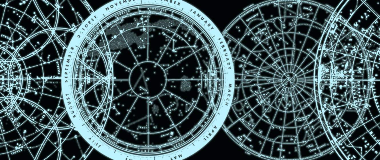
What is a Planisphere?

A planisphere is a simple device that’s somewhat complicated to explain. It’s basically made up of two layers. The bottom layer is a circular map of all the stars and constellations visible from your location. The edge of the map is labeled with the months and dates throughout the year, from January 1st to December 31st.
The top layer acts as a mask that only allows the stars that are currently visible to be seen. Around the edge of this layer are the times throughout the day. In order to see your current view of the night sky, you turn the bottom layer (with the dates) so that today’s date matches up with the current time on the top layer.
In this way, you can literally dial up a date and time and get an idea of how the sky looks at that moment. Once you've set the planisphere correctly, go outside with a red flashlight (a regular white flashlight will ruin your night vision) and then turn to the south. Hold your planisphere above your head so that south is at the bottom, north is at the top, east is on the left and west is on the right. You'll notice that east and west are reversed on the planisphere to match the view you'll see when facing south, and the stars you see should match those on the chart.
You could go outside with your smartphone and point it at the sky. There’s Leo. There’s Cancer. There’s Ursa Major. You can check them off in rapid succession. But where’s the fun in that? It may get you started, but if that’s as far as you go then you’re wading in shallow waters. There’s a whole ocean out there, just waiting to be explored.
There’s nothing wrong with using a GoTo telescope. In fact, a computerized telescope is great if you don’t have much time. Once it’s set up, it will faithfully point you toward something exciting, but, again, you should learn how to properly read a star chart for two important reasons:
1. A star chart will give you a better idea of where to find something exciting.
2. Nothing beats tracking down something exciting and discovering it for yourself.
We find objects in the night sky by a process called star hopping. And we’ll get to that in a moment.
What Coordinates Are Used on a Star Chart?
Star charts, as we know them today, have been around for about four hundred years. At first, they simply plotted the stars with a graphical depiction of the constellation overlaid upon them. As telescopes gained in popularity, astronomers started to discover thousands of much fainter objects that couldn’t be seen with the naked eye.
Known as deep sky objects or DSO’s, astronomers needed a way to accurately record their positions and then plot them on a star chart, so that other observers could find them and enjoy them, too. Simply saying “You can find the Crab Nebula in Taurus by looking just to the upper right of Zeta Tauri” just doesn’t work.
The most obvious solution was to develop a coordinate system for the night sky and the easiest way to do that was to base it on a system already in use. As you’re no doubt aware, we use a coordinate system called latitude and longitude to accurately specify the location of towns, cities and other exciting things (like Disneyland) on a map of the Earth.
For example, Disneyland can be found in Anaheim, California. I could tell you it’s to the south-east of Los Angeles, hidden somewhere within the suburban sprawl of the city, but that probably wouldn’t help you.
But if I told you it was located at 33.8121° N and 117.9190° W, you’d actually have the information you need to find it on a map. Once you find it on a map, you’ll also see that it’s just off exit 110B on the southbound side of the I-5 highway. Now we’ve got an idea of where it’s at, we can plan a route.
We can find deep sky objects in much the same way. Let’s start with the coordinates.
Just as we know the Earth is a sphere, so we can think of the night sky in the same way. (It’s not, but the concept suits our purpose.) Imagine the stars as appearing on a sphere that surrounds the Earth. Now imagine that, as you stand and stare at the stars, you’re actually looking up at the inside of this sphere.
Over the course of the night, the sphere turns so that the stars appear to rise in the east and then later set in the west. This is how, hundreds of years ago, astronomers saw the stars and used the concept as the basis for plotting the positions of the stars.
What is a Star’s Declination?
Instead of using latitude and longitude, they created a system called declination and right ascension. For earthly objects, latitude indicates how many degrees, from zero to ninety, an object is either north or south of the equator. Similarly, declination is also measured in degrees (from zero to ninety) and indicates an object’s position north or south of the celestial equator of our starry sphere.
Objects in the southern celestial hemisphere are typically best seen from our terrestrial southern hemisphere (ie, South America, Australia and most of Africa.) So, for example, the star Alpha Centauri has a declination of -60° 50’ 02” (-60 degrees, 50 arc-minutes and 2 arc-seconds.) Alpha Centauri can be seen from anywhere in the southern hemisphere, but only in the most southerly latitudes of the northern hemisphere.
(Incidentally, there are 60 arc-minutes in a degree and 60 arc-seconds in an arc-minute. It’s a way to more accurately pinpoint an object.)
Any object that’s 90 degrees south (-90°) would appear directly above the southern pole, while an object at 90 degrees north (+90°) would appear directly above the northern pole. Polaris, for example, has a declination of +89° 15’ 51”, which is why it’s called Polaris and is sometimes also known as the North Pole Star.
(There’s no bright star at -90° declination, so there’s no South Pole Star hanging over Antarctica!)
What is Right Ascension?
The celestial equivalent of longitude – right ascension – is a little more complicated. On Earth, zero degrees longitude is an invisible line on a map that runs vertically, pole to pole, straight through Greenwich in London, England. Earthly locations are measured in degrees, either east or west of this line.
On our celestial sphere, the invisible line runs through the constellation of Pisces, the Fishes – and here’s where it gets a little complicated. The reason the line runs through this constellation is because this is the point where the Sun, as part of its annual journey across the sky, crosses the celestial equator from the southern celestial hemisphere to the north.
This happens once a year, around March 20th, on the vernal equinox. In the northern hemisphere, this is the start of spring, while in the southern hemisphere, this is the start of autumn. (Incidentally, the word equinox means “equal night” – a fitting description for the time when the days and nights are of equal length.)
The big difference between longitude on Earth and right ascension on the celestial sphere is how they’re measured. Longitude is measured in degrees while right ascension is measured in hours, minutes and seconds: from zero hours, zero minutes and zero seconds (where the Sun crosses the celestial equator) eastward to 23 hours, 59 minutes and 59.9 seconds (or as close to 24 as you can get!)
It sounds confusing – and at first it is – but it works in the same way as longitude. Any object in the night sky, whether it moves or remains stationary, can be plotted and located using right ascension and declination.
For example, Sirius, the brightest star in the sky, has a right ascension of 06h 45m 09s and a declination of -16° 42’ 58”. You can see it from most of the northern hemisphere, but it’s actually best seen from the south.
How a Star Chart Can Help You Star Hop

So now you know the coordinates of something exciting in the night sky, but maybe it’s too faint to be easily found. This is where a star atlas comes in handy.
Each page of the atlas focuses on a specific area of the night sky. Each atlas will vary a little, but there’s typically an index of constellations and objects referring you to the relevant chart. When you turn to that chart, you’ll see the stars represented as black dots on a white background. (This makes the chart a lot easier to read when you’re outside at night.)
The size of the dot indicates the brightness of the star; the larger the dot, the brighter the star. You’ll also see other symbols, such as grey circles to show star clusters and ovals to represent galaxies.
You’ll see the hours of right ascension marked along the top and bottom of the page while degrees of declination are marked along the sides. There are lines connecting them, just as you’d see lines connecting latitude and longitude in an atlas of the Earth.
So let’s look for something exciting. In the constellation of Leo, the Lion, there’s a trio of bright galaxies that can easily be seen with a small telescope under reasonably dark skies. (In other words, not the suburbs.)
Also known as the Leo Triplet, these galaxies are about 35 million light years away and can be seen together through a low powered eyepiece. Of the three, Messier 66 (M66) is the brightest and can be found at right ascension 11h 20m 15s and at declination +12° 59’ 29”.
Look in a star chart and you’ll find them close to Theta Leonis, also known as Chertan. This star is easily seen to the naked eye and marks the back leg of the lion. If you’ve learned your constellations, you’ll also know that Leo is typically best seen throughout the spring in the northern hemisphere (autumn in the southern.)
If you haven’t learned your constellations, you probably won’t know that and might set out on your journey at the wrong time of year.
A star chart, like an atlas of the Earth, has north toward the top of the page, so we can see that the Leo Triplet (M65, M66 and NGC 3628) can be found just to the south of Chertan. Your finder scope might not have enough magnification to pick out the galaxies so we can star hop to our destination instead.
Star hopping is where you start from an easily seen, bright star and then progressively hop over to other (typically fainter) stars until you find something exciting. This is one of the best things about astronomy. If you’ve never seen an object before, you can track it down in much the same way that hunters will follow footsteps to their prey.
If we look a little to the south of Chertan, we can see another, fainter star – 73 Leonis. Just to the east of 73 (or left, on the star chart) is the Leo Triplet. If you center 73 Leonis in your finder scope and use a low powered eyepiece, you should be able to faintly see the galaxies close to the star.
Remember, these galaxies are 9-35 million light years away and you’re looking at them as they were before humankind even existed. Nothing beats the sense of achievement you get when you take the time to learn the constellations and track down something exciting for yourself.
Sometimes it’s still fun to set off without a plan and find the celestial equivalent of Disneyland. And you’ll often find something exciting along the way too; so you make a note of the constellation where you found it and the nearest bright star and then you retrace your steps on a star chart to see what you’ve discovered.
When I lived under those dark skies of Oklahoma, I made it my mission to track down something exciting almost every clear night. I didn’t have a GoTo telescope at the time and when I did eventually get one, I found I used it a lot less than I thought I would. I preferred to discover the exciting things for myself and although I didn’t always succeed, I was rarely disappointed. You can find Disneyland on almost any night; if you know where to look for it.
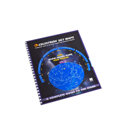
Want to search for the stars on your own? Our non-commissioned product advisors recommend the Celestron Sky Map.

Click the arrow above to see MLA, APA, and Chicago Manual of Style citations.
MLA:
Bartlett, Richard. "How to Read a Star Chart," AstronomyHub, High Point Scientific, 12 Jul. 2019, https://www.highpointscientific.com/astronomy-hub/post/how-to-read-a-star-chart.
APA:
Bartlett, R. (2019, July 12). How to read a star chart. High Point Scientific. https://www.highpointscientific.com/astronomy-hub/post/how-to-read-a-star-chart
Chicago Manual of Style:
Bibliography:
Richard Bartlett. "How to Read a Star Chart," AstronomyHub (blog), High Point Scientific, July 12, 2019. https://www.highpointscientific.com/astronomy-hub/post/how-to-read-a-star-chart.
Footnote:
Richard Bartlett, "How to Read a Star Chart," AstronomyHub, High Point Scientific, July 12, 2019, https://www.highpointscientific.com/astronomy-hub/post/how-to-read-a-star-chart.